Friday, July 18, 2008

Ooops!


Seems like I made a wrong turn somewhere in Utah and 1700 miles later have ended up in Indiana!!

The journey isn't over, it has simply been detoured for a little while.

I'll be back...

Wednesday, July 16, 2008

Happy little creek

Happy little creek at different times of the year, from the same vantage point (approximately):


Late March.


Mid-April.


Now. (Pre-Katrina.)


Flood stage, early April.

A reminder on crampon fitting....

Just got in two new pairs of boots as I get ready to go to Canada for 10 days of testing,photos and climbing.


I'll take 5 pairs of boots and 5 different crampons to climb in this trip as I attempt to see where I am at physically and mentally.


As I spend the evening fitting crampons this commentcomes to mind,


"Precision crampon technique is impossible without a proper (perfect) fit of boot to crampon."

Jeff Lowe from the WATERFALL ICE video, 2005.


In other words, if your crampons won't stay on the boots first, without latching the binding, likely the crampon doesn't really fit your boot.


Finally some one gets (again) how it is suppose to be. No tricks just a perfect friction fit.

Petzl Lynx on a Scarpa Phantom Ultra and no back binding.


Monday, July 14, 2008

Fort Lewis Chinook Pilots Climb to Summit

Pilots Richard Bovey, Bryan Campbell and Scott Salkovics from the 159th alpha Company Army Reserve, accompanied by two climbing rangers, spent four days at Mount Rainier training and climbing to the summit via the Emmons Winthrop Route. All three men have trained at Mount Rainier in high altitude rescue and provided critical support in Search and Rescue. In addition to their assistance with SARs, Bovey, Campbell and Salkovics are also huge supporters and fans of Mount Rainier. Bovey and Campbell have done volunteer work to help restore two of the lookout towers and all are avid outdoorsmen. Although they have all hiked in the Park extensively (Campbell completed the Wonderland Trail in a seven day period) none had summitted Mount Rainier.

This trip afforded the pilots the opportunity to look at many of the training and rescue locations on the ground, as well as train in crevasse rescue, glacier travel and route finding on the upper mountain. The conditions for the climb where ideal - great weather, excellent food and lodging (the hut and barbecue at Camp Schurman). This is a special thanks to them and to the U.S. Army unit that supports climbers and search and rescue operations on Mount Rainier. There is more information about the unit and its work from previous trainings and missions.

Photo and post by David Gottlieb

ANT Headbadge in the Making

Making an ANT Headbadge

Visiting ANTyesterday, I got to see something very cool: The making of a headbadge from start to finish. The ANTheadbadgelooks like a piece of antique jewelry - resembling an oxidised copper brooch. I've been wondering how Mike Flanigan makes them, and now I know:


Making an ANT Headbadge
Turns out the headbadges are brass, not copper. While initially Mike made them by hand, for years now he has been getting them laser-cut in batches. But on this occasion he needed a headbadge for a bike with a short headtube, so he made a smaller one from scratch, starting with a blank plaque.


Making an ANT Headbadge
The headtube was not only small, but had decorative lugwork around the edges, limiting the space for the badge quite a bit.To start with, Mike measured the available space and cut down one of the blanks to size with a saw.


Making an ANT Headbadge
Using one of the laser-cut badges as a model, he then drew the design on the smaller blank freehand in black marker. Because of the difference in scale, the ant on the smaller badge came out slightly differently - chubbier and shorter, with a rounded head. We decided it was a juvenile ant.


Making an ANT Headbadge
Not sure whether this is obvious, but the rendering of the insect actually spells "ANT" - the head being the "A," the torso the "N" and the bottom the "T." It's a clever logo.


Making an ANT Headbadge

Using a variety of files and an awl, Mike carved out the ant and "distressed" the plaque.


Making an ANT Headbadge

The remaining traces of marker were then removed and the surface smoothed down.


Making an ANT Headbadge

Once the headbadge was ready, the patina was applied. This is the stuff that gives the headbadge the look of oxidised copper.


Making an ANT Headbadge

This is a liquid patina goes on blue, but turns rusty-green as it air-dries. The process can be speeded up by putting the patina-covered headbadge in a plastic bag for a few minutes.


Making an ANT Headbadge

As the "oxidation" completed, Mike attached the badge to the headtube and it was done. The process took about 30 minutes total and was pretty exciting to watch. I don't think that many headbadges are carved out freehand anymore, and doing it this way gives them a distinctly hand-made look. A big thank you to Mike for letting me observe and share the process!

Monday, July 7, 2008

Big Bend Revisited :: Chisos Basin

Thursday, February 28th - - It was about 180 miles from Seminole Canyon State Park to the northern entrance of Big Bend National Park. At 10:30 when I finally left Seminole Canyon, the temperature was 57 degrees with a few clouds, lots of blue skies and sunshine.


Once you get to the entrance of Big Bend, it is another 30 miles to the visitor center at Panther Junction, then another 24 miles to the Rio Grande Village area in the eastern side of the park. The road to Rio Grande Village is mostly downhill - it takes you into the "lower" portion of the park - and the temperature went from a cool 60 degrees to a much warmer 69. Yeah, that was nice!


I picked out my campsite, which was to be "home" for the next four nights. The campground was not full by any means and there were plenty of sites to choose from whether you wanted one "out in the open" or more secluded along the southern section (as I did). As usual in most National Parks there are no hookups for electricity or water in the "main" campground. However, Big Bend does have an "RV" area with hookups but it is pretty much a parking lot.


Friday, March 1st - - It got quite cold during the night, as expected, and it sure would have been nice to have a little heater to take the chill out of the air. Instead, I just stayed in the sleeping bag a little longer than usual...


It was still chilly when I finally got up, but it was quite comfortable sitting in the sunshine and eating my breakfast. I decided to drive up to the Chisos Basin area, stopping along the way for some photos...


Looking to the West, from about 5 miles east of the Panther Junction visitors center.


Somewhere along the lower portion of the road to Chisos Basin. It's about 8 miles once you turn off the main road to Chisos Basin. The road goes uphill, winding its way through the mountains, gaining several thousand feet in elevation, and making several hairpin turns. The road is not recommended for vehicles pulling trailers longer than 20 feet or for RVs more than 24 feet long.


I don't think there have been any recent bear sightings, but mountain lions were seen in several areas earlier in February. One was even sighted along the Window View Trail not far from the visitors center and the Chisos Lodge.


Once you get to the highest point along the highway, you then start going down into the basin area. Hidden out of view are the campground and Chisos Mountain Lodge.


Traveling a little further along the road, the campground area comes into view. I stayed there for five nights on my visit in February ... The vehicles look so tiny compared to the mountains surrounding them.


The view through the "window" from the Window View Trail near the visitor center and Chisos Mountain Lodge.


My visit this year would be very different than it was in .., and shorter. My legs can't handle the long hikes as well as they did three years ago and I am pitifully out of shape. Nevertheless, the visit this year was very enjoyable and more relaxing, and of course, there will be more posts/photos to come. Below is a list of the posts from the .. visit I thought you might enjoy reading again (or perhaps, for the first time) - I was far more adventurous then!


  • February 20, .. - Chisos Basin (posted March 10th)

  • February 21, .. - Lost Mine Trail (posted March 11th)

  • February 22, .. - Laguna Meadows Trail (posted March 12th)

  • February 23, .. - Snow in the Chisos (posted March 13th)

  • February 24, .. - The Window Trail (posted March 14th)

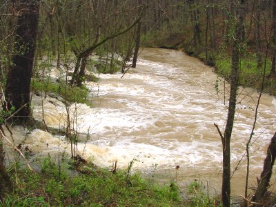
  • February 25, .. - Rio Grande Village (posted March 15th)

  • February 26, .. - Down by the River (posted March 16th)

  • February 27, .. - Hot Springs Trail (posted March 17th)

  • March 1 & 2, .. - Cerro Castellan (posted March 19th)

  • March 1 & 2, .. - Castolon Homesteads (posted March 20th)

  • March 1 & 2, .. - Santa Elena Canyon (posted March 21st)


Wednesday, July 2, 2008

The Grand Canyon of the Yellowstone

Thursday, September 1st - - With the campsite in shade and temperatures in the low 30s this morning I went and found a nice sunny spot in which to eat breakfast. Then it was off to see the sights!


Sometimes, I guess, Buffalo prefer an easy route to wherever they are going! They were frequently seen alongside and on the road, usually only one or two bison at a time.


My primary destination this morning was the Grand Canyon of the Yellowstone with its beautiful Lower Falls and Upper Falls. Located at the northeastern corner of the southern highway loop, the 40 mile drive from the campground took about two hours, with stops along the way at the Mud Volcano Area and Sulphur Caldron.


My first stop in the “Grand Canyon” area was Artist Point on the South Rim.


Artist Point provides stunning views of the 308-foot Lower Falls. It is, quite simply, breathtaking! The morning light along with a hazy sky enhanced the view allowing details in the sides of the canyon to show up, though the colors are somewhat muted.


A closer view of the Lower Falls.


And, even closer.


The colors of the canyon didn't show up clearly in the photos of the Lower Falls, but, oh my, how they “popped” when looking to the northeast! The fantastic colors of the north side of the canyon come from rhyolite and sediments that have been altered by hydrothermal action (i.e. hot water from springs that were active in years past).


The Upper Falls is not quite as impressive (only 109 feet) or photogenic as the Lower Falls but it was still worth the walk down a short trail to see it.


It was also easier to access the Brink of the Upper Falls from another short trail. The Brink of the Lower Falls was a strenuous trail that dropped 600 feet in a very short distance. I passed on that one but did go to the Brink of the Upper Falls, shown above.


The view from Inspiration Point, on the North Rim, looking to the northeast.


As I drove up to the northwest side of the park to the Mammoth Hot Spring Terraces, the clouds moved in.


I walked along most of the boardwalk trails in the lower terraces but my legs were getting a little wobbly by the time I made it to the upper terrace area. Whether it was from the lighting conditions or the fact that many of the springs in that area have gone dormant, I was disappointed with my visit there. The photos I took were rather blah.


The view from the front of the upper terraces was rather impressive though. On the drive back to the campground, I took the “shorter” route along the west side of the northern loop then cutting across to Canyon Village and the eastern side of the southern loop. It was still about a 75 mile drive back to the campground.